PanoramaTrail on Mount Penken in Mayrhofen

PanoramaTrail on Mount Penken in Mayrhofen
0
Easy
Distance km
Duration 45 min

Trail characteristics

Asphalt
Hiking trail

Best Season

Elevation

Min 1,800 m
Max 1,983 m
Uphill 195 m

Route description

©Mayrhofner Bergbahnen

The PanoramaRundWeg on the Penken is a circular tour suitable for baby carriages in the heart of the Mayrhofen mountains. Over a distance of around two hours, it connects the mountain stations of the Kombibahn Penken and the Penkenbahn.

Starting points and route

The PanoramaRundWeg, which is suitable for baby carriages, starts either at the Kombibahn Penken mountain station or at the Penkenbahn mountain station - both options are possible and can be chosen according to preference. From the Kombibahn, the approximately two-hour route (there and back) first runs uphill towards Penkenjoch, the highest point of the tour, before leading in a wide arc along well-maintained, low-barrier paths back to the Penkenbahn.

The circular route is well signposted throughout and offers gentleclimbs, varied scenery and magnificent views of the Zillertal Alps.

Tip for families: be sure to plan a stopover at the FunSportStation. Mountain scooters, an e-trial course, a motor skills course and a varied mountain playground await here - ideal for an active break and great fun for young hiking fans.

Suitable for dogs
Suitable for kids

Video

Mayrhofen - Der Penken | 03:26

Highlights of the tour

The PanoramaRundWeg offers the best views of colorful paragliders in the sky.
© Mayrhofner Bergbahnen The PanoramaRundWeg offers the best views of colorful paragliders in the sky.

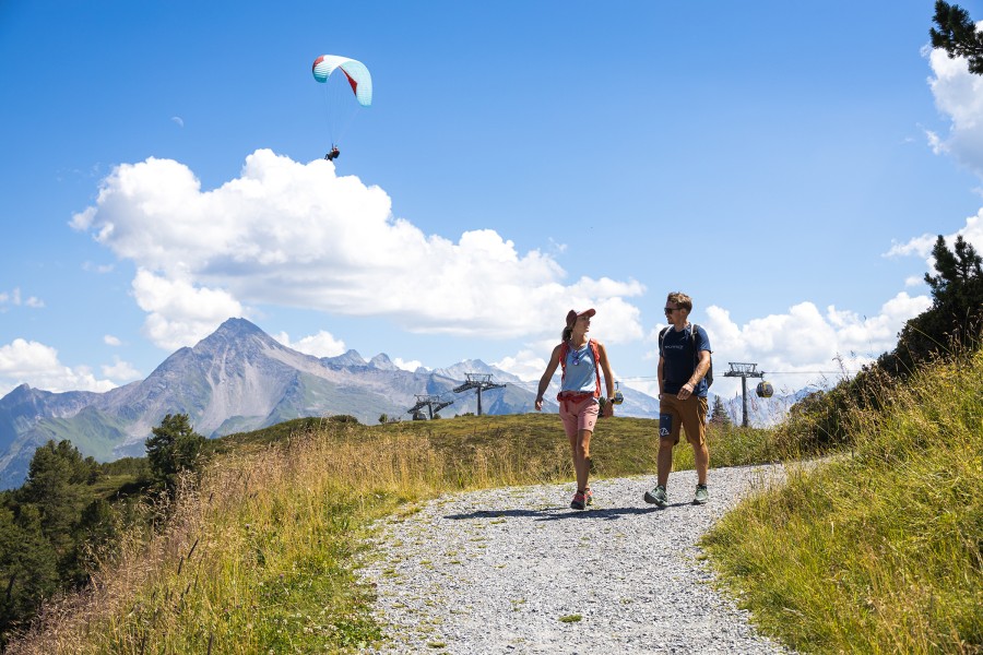
The trail leads past some of the most spectacular sporting venues on the Penken. On the Knorren massif, climbers can be observed against a steep rocky backdrop, while colorful paragliders regularly take to the skies at the two launch sites. A real hotspot for all those who want to experience alpine thrills live - from the comfort of the hiking trail.

Getting here

To reach the PanoramaRundWeg on the Penken, first take one of the two cable cars from Mayrhofen to the top: either the KombibahnPenken or the Penkenbahn. Both take you comfortably to the mountain station and thus directly to the start of the circular trail.

The valley stations are located on the southern outskirts of Mayrhofen in the Zillertal. If you are traveling by car, take the Inntal freeway (A12) to the Zillertal exit and then follow the B169 through the valley to Mayrhofen. In the village, the access road to the cable cars is well signposted. Parking spaces are available directly at the valley station.

You can easily reach Mayrhofen by public transport on the Zillertalbahn from Jenbach. From Mayrhofen train station, it's just a few minutes' walk to the valley stations - or you can use the free summer shuttle run by Mayrhofner Bergbahnen, which runs regularly.

Image Gallery

See all images

Webcams

Weather

Print & Downloads

Contact

Mayrhofner Bergbahnen AG
Ahornstraße 853
6290
Mayrhofen
E-Mail
%69%6e%66%6f%40%6d%61%79%72%68%6f%66%6e%65%72%2d%62%65%72%67%62%61%68%6e%65%6e%2e%63%6f%6d
+43 5285 62277

Comments

Rate the Hike
No posts available yet:
  • Nobody has posted on the wall of the Hike "PanoramaTrail on Mount Penken in Mayrhofen" yet
  • Be the first to comment!

Nearby

last update on 7 Jan 2026