Around Me
Search
List
Map
Combined
Guide
Guide
Europe
Germany
Austria
Italy
Switzerland
France
Spain
Greece
Great Britain and Northern Ireland
Czech Republic
Liechtenstein
Iceland
Romania
Belgium
Hungary
Portugal
Slovakia
Ireland
Netherlands
Denmark
Norway
Finland
Malta
Slovenia
Sweden
Serbia
Lithuania
Poland
Ukraine
North America
USA
Canada
Costa Rica
Oceania
New Zealand
Australia
Africa
Egypt
South Africa
Asia
Japan
United Arab Emirates
China
Iran
Russia
Turkey
India
Azerbaijan
Georgia
South America
Brazil
Hiking
Hiking
Europe
Austria
Germany
Italy
Switzerland
Liechtenstein
France
Iceland
Romania
Belgium
Ireland
Norway
Great Britain and Northern Ireland
Denmark
Sweden
Portugal
North America
USA
Canada
Oceania
New Zealand
Australia
Biking
Biking
Europe
Austria
Germany
Switzerland
Italy
Liechtenstein
Romania
Spain
Great Britain and Northern Ireland
Lithuania
Finland
France
Iceland
Ireland
North America
Canada
USA
Swimming
Swimming
Europe
Austria
Germany
Switzerland
Italy
Romania
Iceland
Hungary
Slovenia
Spain
Belgium
Great Britain and Northern Ireland
Malta
Ireland
Netherlands
North America
Canada
USA
Attractions
Attractions
Europe
Germany
Austria
Italy
France
Switzerland
Spain
Greece
Czech Republic
Slovakia
Portugal
Great Britain and Northern Ireland
Hungary
Belgium
Netherlands
Iceland
Ireland
Denmark
Liechtenstein
Norway
Finland
Malta
Romania
Serbia
Slovenia
Sweden
Ukraine
Poland
North America
USA
Canada
Costa Rica
Oceania
New Zealand
Australia
Africa
Egypt
South Africa
Asia
Japan
United Arab Emirates
China
Turkey
Russia
Iran
Georgia
India
Azerbaijan
South America
Brazil
Magazine
Magazine
News
Award
Active
Culture
Tips
Specials
On Tour
Inside
Deutsche Version
Home
Map
The Perfect Match
Sweepstakes
Packages & Deals
My TouriSpo
Login
Sign Up • It's free
Europe
Austria
Tyrol
Salzburg
Salzburg's world of sport
Grossarltal
Gasteinertal
Zell am See - Kaprun
Saalbach-Hinterglemm
Lungau
Hochkönig
Nationalpark Hohe Tauern
Obertauern
Saalfelden-Leogang
Saalachtal
Vorarlberg
Styria
Carinthia
Upper Austria
Lower Austria
Vienna
Burgenland
Germany
Italy
Switzerland
Liechtenstein
France
Iceland
Denmark
Romania
All countries in Europe
Great Britain and Northern Ireland
Belgium
Norway
Ireland
Sweden
Portugal
North America
Canada
USA
Oceania
New Zealand
Australia
Magazine
News
Award
Active
Culture
Tips
All magazine categories
Specials
On Tour
Inside
Vacation Deals
Special Offers
Misc.
The Perfect Match
Travel Guide
Map
Sweepstakes
Surveys
Austria
Salzburg
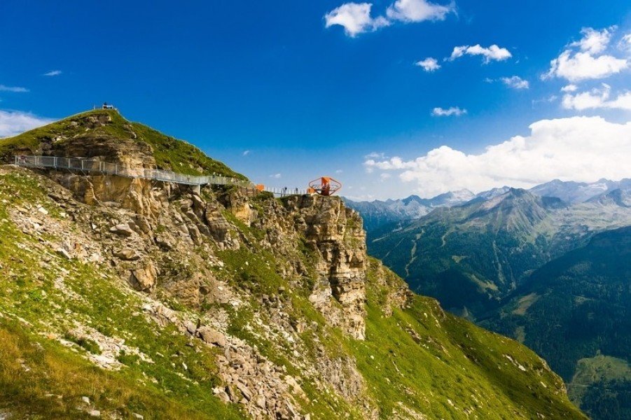
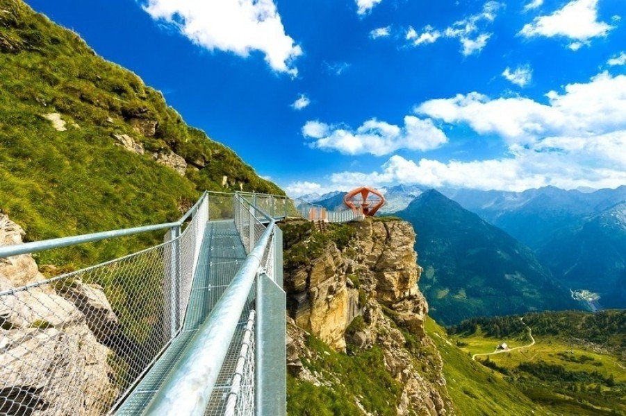
Rock Trail Stubnerkogel Bad Gastein
Hike
Weather For Hikers
Webcams
Home
Photos
Wall
Rock Trail Stubnerkogel Bad Gastein
Hike
Photos
Weather For Hikers
Webcams
0
0 stars
0.5 stars
1 star
1.5 stars
2 stars
2.5 stars
3 stars
3.5 stars
4 stars
4.5 stars
5 stars
Advertisement
Easy
Distance
1
km
Duration
30 min
Start:
N/A
Loop trail
Trail characteristics
Hiking trail
Experts only
Best Season
JAN
FEB
MAR
APR
MAY
JUN
JUL
AUG
SEP
OCT
NOV
DEC
Elevation
Max
2,217
m
Image Gallery
© Gasteiner Bergbahnen AG
© Gasteiner Bergbahnen AG
See all images
Webcams
All Webcams
Weather
Today
-8/
3
°C
Thu
-11/
-9
°C
Fri
-12/
-10
°C
Sat
-13/
-5
°C
Sun
-11/
-7
°C
Weather Forecast
Print & Downloads
Print Version
Contact
Gasteiner Bergbahnen AG
Bundesstraße 567
A-5630
Bad Hofgastein
E-Mail
www.skigastein.com
%69%6e%66%6f%40%73%6b%69%67%61%73%74%65%69%6e%2e%63%6f%6d
+43 (0)6432 6455 - 0
Comments
Rate the Hike
0 stars
0.5 stars
1 star
1.5 stars
2 stars
2.5 stars
3 stars
3.5 stars
4 stars
4.5 stars
5 stars
Send
No posts available yet:
Nobody has posted on the wall of the Hike "Rock Trail Stubnerkogel Bad Gastein" yet
Be the first to comment!
Nearby
Thermal bath Felsentherme Bad Gastein
0.4
km
Stubnerkogel & Tischkogel summit
0.7
km
Bad Gastein - Graukogel summit
0.8
km
Bad Gastein - Gamskarkogel Mountain
2.3
km
Drei Waller Hiking Trail Dorfgastein
2.3
km
Stone Pine Hike at Graukogel
2.4
km
Rock Trail Stubnerkogel Bad Gastein
3.5
km
Circular Hiking Trail from Angertal to Gadaunerer Hochalmen
4.6
km
Gasteiner Höhenweg
6.7
km
Hiking Path to Reitalm - Huettschlag
9.3
km
Alpe Adria
78.1
km
Gasteiner Bergbahnen AG
last update on 8 Oct 2024