Around Me
Search
List
Map
Combined
Guide
Guide
Europe
Germany
Austria
Italy
Switzerland
France
Spain
Greece
Czech Republic
Great Britain and Northern Ireland
Liechtenstein
Iceland
Romania
Belgium
Hungary
Portugal
Ireland
Slovakia
Netherlands
Denmark
Norway
Finland
Malta
Sweden
Slovenia
Serbia
Lithuania
Poland
Ukraine
North America
USA
Canada
Costa Rica
Oceania
New Zealand
Australia
Africa
Egypt
South Africa
Asia
Japan
United Arab Emirates
China
India
Azerbaijan
Georgia
Iran
Russia
Turkey
South America
Brazil
Hiking
Hiking
Europe
Austria
Germany
Italy
Switzerland
Liechtenstein
France
Belgium
Iceland
Romania
Norway
Ireland
Great Britain and Northern Ireland
Denmark
Sweden
Portugal
North America
USA
Canada
Oceania
New Zealand
Australia
Biking
Biking
Europe
Austria
Germany
Switzerland
Italy
Liechtenstein
Romania
Spain
France
Great Britain and Northern Ireland
Lithuania
Finland
Iceland
Ireland
North America
Canada
USA
Swimming
Swimming
Europe
Austria
Germany
Switzerland
Italy
Romania
Hungary
Iceland
Slovenia
Spain
Belgium
Netherlands
Great Britain and Northern Ireland
Malta
Ireland
North America
Canada
USA
Attractions
Attractions
Europe
Germany
Austria
Italy
France
Switzerland
Spain
Greece
Czech Republic
Great Britain and Northern Ireland
Slovakia
Portugal
Hungary
Belgium
Netherlands
Iceland
Ireland
Denmark
Malta
Liechtenstein
Norway
Finland
Romania
Serbia
Sweden
Slovenia
Poland
Ukraine
North America
USA
Canada
Costa Rica
Oceania
New Zealand
Australia
Africa
Egypt
South Africa
Asia
Japan
China
United Arab Emirates
Azerbaijan
Turkey
Russia
Iran
Georgia
India
South America
Brazil
Magazine
Magazine
News
Award
Active
Culture
Tips
Specials
On Tour
Inside
Deutsche Version
Home
Map
The Perfect Match
Sweepstakes
Packages & Deals
My TouriSpo
Login
Sign Up • It's free
Europe
Austria
Tyrol
Salzburg
Vorarlberg
Styria
Carinthia
Lavanttal
Nassfeld-Pressegger See - Lesachtal - Weissensee
Upper Austria
Lower Austria
Vienna
Burgenland
Germany
Italy
Switzerland
Liechtenstein
France
Iceland
Denmark
Romania
All countries in Europe
Great Britain and Northern Ireland
Belgium
Norway
Ireland
Sweden
Portugal
North America
Canada
USA
Oceania
New Zealand
Australia
Magazine
News
Award
Active
Culture
Tips
All magazine categories
Specials
On Tour
Inside
Vacation Deals
Special Offers
Misc.
The Perfect Match
Travel Guide
Map
Sweepstakes
Surveys
Austria
Carinthia
Webcams around the Hike Crystal Trail – Leg 4: Weinebene – Großer Speikkogel – Brandl (Lavanttal)
Hike
Weather For Hikers
Webcams
Crystal Trail – Leg 4: Weinebene – Großer...
Hike
Photos
Weather For Hikers
Webcams
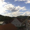
Town of Lavamünd
Elevation:
343
m
The town of Lavamünd is located in between the rivers Drau and Lavant, near the...
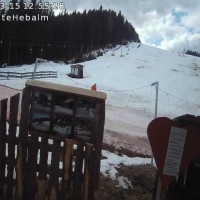
Hiking Area Hebalm - Styria
Elevation:
1,386
m
View of the hiking area Hebalm around the Rehbock hut (Styria).
Weinebene: Snowpark
Elevation:
1,696
m
View of Snowpark in Weinebene Ski Resort
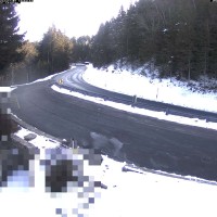
Lavamünd - Meeting point for bikers
Elevation:
1,335
m
At the Highwaay 69 in the north of Lavamünd, there is this webcam which is directed...
Steinschneider lift on Koralpe
Elevation:
1,877
m
Located at Steinschneider lift on Koralpe (Carinthia, Austria) you can see the...
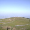
Koralpe: Base Station
Elevation:
1,831
m
View of base station Koralpe in Carinthia, Austria.
Webcam is Missing
A webcam is missing? Do you know the source of another one?
E-Mail
Message
Slide to the right to submit the form!
Send
Webcam Information
6 webcams are located near the Hike Crystal Trail – Leg 4: Weinebene – Großer Speikkogel – Brandl.
The highest webcam (
Steinschneider lift on Koralpe
) is situated 1877 metres above sea level, wheras the lowest webcam (
Town of Lavamünd
) is situated 343 metres above sea level.
Most popular webcam in the Hike Crystal Trail – Leg 4: Weinebene – Großer Speikkogel – Brandl's vicinity:
Town of Lavamünd
.
All Webcams on the map