

Route description

Through Johnston Canyon
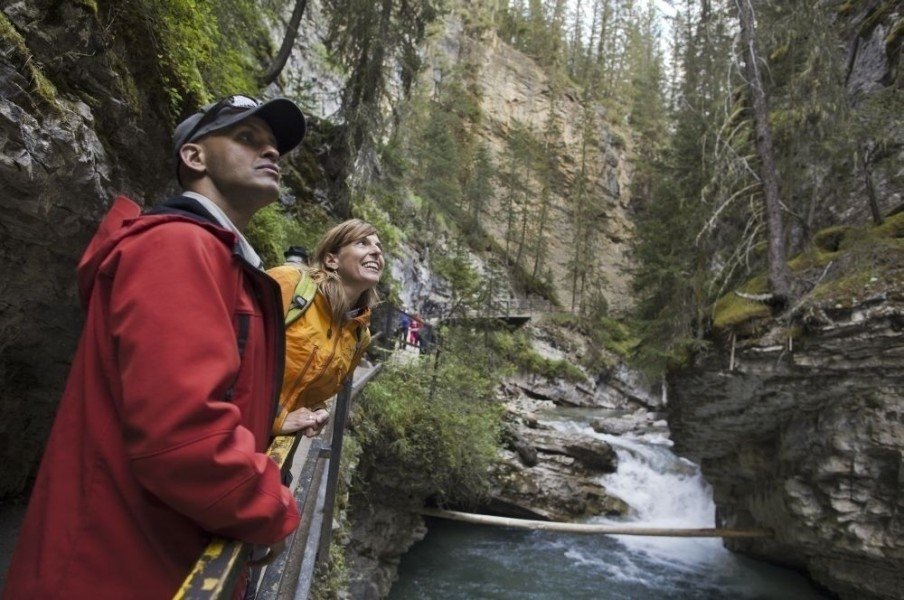
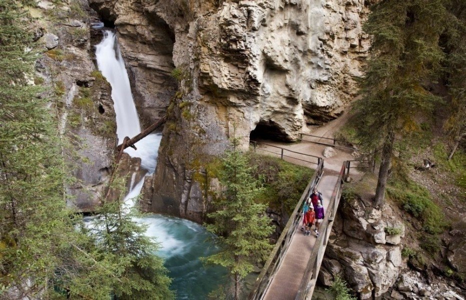
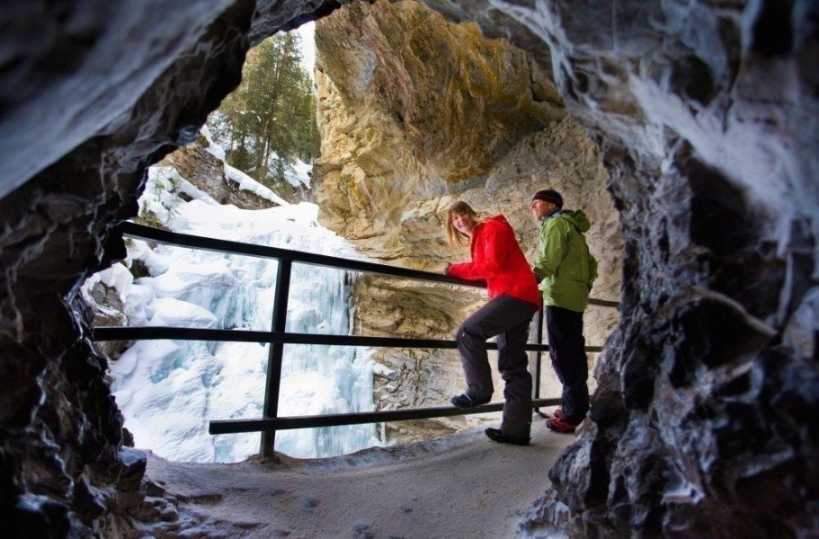
The hike through Johnston Canyon is probably one of the best-known and picturesque trails in all of Banff National Park. It should therefore come as no surprise that the path is often relatively busy, both at the weekend and during the week. The walking path starts at the canyon car park, passing the toilet block before entering the canyon just a few metres further on. Next, the route crosses a bridge before passing a small lodge and a couple of huts. Here, keep right to take the trail to the Lower Falls. After just one kilometre, you will reach the waterfalls which descend some 10 meters. There is even a small tunnel on one side of the falls which you can crawl through on your knees if you’re keen on getting within touching distance of the rushing water.
Onwards to the Upper Falls
After that, the trail continues uphill, scaling around 120 meters of vertical difference before reaching the Upper Falls after roughly 2.7 kilometres. This waterfall is even more dramatic than the Lower Falls – measuring some 30 meters in height, it is a pretty impressive natural spectacle. From these falls, the trail heads on up the valley for another 3.5 kilometres to the so-called Ink Pots. Although many hikers do not walk this additional section of trail, the extra distance is definitely worth your while. The walking path winds its way through the forested landscape, moving away from the actual canyon. After a while, you will reach a crossroads in the path where you should keep right, following the very well signposted route.
The Ink Pots at the end of your tour
Although the trail to the Ink Pots is often described as a basic forest path, it has sections with gravel under foot and is therefore easy to walk. The first 3 kilometres lead through the forest before the trail moves out of the trees and into Johnston Valley. Here, your effort is rewarded with stunning views of the surrounding mountains. You will also be able to spot the Ink Pots themselves by this point – made up as they are of six small, shimmering green ponds which are filled with fresh spring water. The bubbles created by the springs are clearly visible in every pool, making this a great conclusion to the tour.
Where to eat
Apart from the lodge at the start of the tour, we know of no options for buying food or drink during the hike, so we recommend taking a packed lunch and some refreshments.
Interesting facts
- You're traveling a distance of 12 km on this moderate trail. The average length of all hikes in Alberta is 19 km.
- You're facing an uphill climb of 322 vertical meters on this hike. The highest point of the track is 1,743 m above sea level.
- Make sure to bring sturdy footwear on this track. Hiking boots are highly recommended.
Highlights of the tour
The Upper and Lower Falls are a real natural spectacle embedded within this wild landscape. The Ink Pots springs are also memorable, while the outstanding views from the trail make the extra hike well worthwhile.
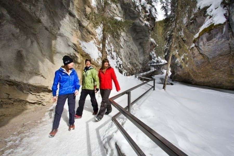
In addition, visitors also have the option of taking so-called “guided ice walks” along this route during the colder months. As parts of the waterfalls often freeze in Canada’s icy winter temperatures, these tours offer the unique opportunity to experience the frozen landscape first-hand with a trained guide.
Equipment
If you would like to take part in one of the winter ice walks, please ensure that you wear warm clothing and sturdy footwear.
Getting here
By car
From Calgary
From Calgary, first follow the Bow Trail west out of the city before turning right at the crossroads with the Sarcee Trail. After a short period of time, turn onto the Trans-Canada Highway towards Banff and follow this until you can take the exit towards Bow Valley Parkway. After exiting at the ramp, keep west and follow the road for around 18 km until you reach the Johnston Canyon car park which is located to the right of the road.
From Jasper
If you are starting from Jasper, first take Connaught Drive west out of the city. Now you cross the Yellowhead Highway and find yourself on Icefields Parkway. Follow this for the next 285 km – a route which leads you through both Jasper National Park and parts of Banff National Park. When you reach Lake Louise, turn onto the Trans-Canada Highway before taking the exit towards Castle Junction a short time later, which is located halfway between Lake Louise and Banff. After taking this exit, you should then turn left and follow the signposts for Castle Junction to the next T-junction, where you turn right onto Highway 1A towards Bow Valley Parkway. Here, you will start to see signposts for Johnston Canyon, which you then reach after around 6 km of driving.
From Lethbridge
From Lethbridge to the south, first take Scenic Drive out of the city, which leads you to the ramp onto Crowsnest Highway (Highway 3) which you should follow towards Calgary. After around 18 km, take a slight right and follow signposts for Monarch/Vulcan. This takes you onto Highway 23 which you should follow until the left turn towards Claresholm. In Claresholm itself, turn left and follow the signposts towards Calgary/Nanton. You will then join the Queen Elizabeth Highway (Highway 2) which first heads through Nanton and past Silver Lake, continuing north. You should then keep right to take the Deerfoot Trail which you then exit in the first outskirts of Calgary onto Southland Drive. You then keep on Southland Drive for a short time before turning right onto the Blackfoot Trail. This then leads to the ramp for the Glenmore Trail which you should follow for about 8 km through the city before joining the Sarcee Trail. After that, switch onto the Trans-Canada Highway towards Banff and continue on this road until the exit towards Bow Valley Parkway. After taking this ramp, keep west and follow the road for around 18 km until you reach the Johnston Canyon car park which is located on the right.